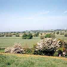
2.1 Landscape of the Parish
The villages and hamlets within the Parish are
set within an attractive landscape. This comprises a landform
of visually prominent wooded scarp slopes and mainly pasture
ridges on limestone which form a contrast with broad valley
forms and extensive levels extending towards the Severn Estuary7.
Amongst the watercourses flowing through the valley to the
Pilning Levels are Olveston Mill Rhine and Tockington Mill
Rhine with their tributaries.
One ridge extends to Alveston immediately north
of the Parish, through Tockington Hill, Old Down and Stroud
Common. The wooded scarp slopes, which include Sheepcombe
Brake, The Slad and Little Down Wood, provide part of the
setting and backcloth to the hamlet of Old Down and the villages
of Olveston and Tockington. Old Down lies on the ridge. Olveston
lies between the ridge and the somewhat lower Catherine and
Eastcombe Hills. Tockington lies to the south alongside the
grounds of Tockington Manor School with its historic garden
and arboretum.
Another ridge extends from Rudgeway to Almondsbury
mostly just outside the Parish. There are areas of woodland
on the high ground along the A38 providing a visual foil to
the intermittent houses alongside the road.
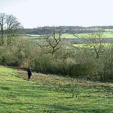
Between these ridges lies the unspoilt Sheepcombe
Valley with arable fields along the bottom and pasture and
rough grassland on the valley sides enclosed by woodlands
and hedgerows. This valley extends from Lower Hazel towards
the M4 motorway embankment with views to Spaniorum Hill and
the industry at Avonmouth beyond.
To the south west of Olveston and Tockington
lie the Pilning Levels which are predominantly flat with a
few small areas of higher ground. The area is largely covered
by pasture fields bounded by hedges with some trees and small
copses.
The field pattern is partly defined by the pattern of rhines
flowing towards the Severn Estuary. There are small settlements
based around clusters of farmsteads at Ingst and Awkley on
locally higher ground.
The Levels are crossed by the M4 and M48 motorways linking
to the two Severn bridges.
The whole of the Parish is connected by a network of minor
roads and lanes and an intermittent network of public rights
of way8.
|